Empakaai crater ngorongoro conservation area, Tanzania
 Empakaai crater of Ngorongoro conservation area, view from a point on its eastern rim
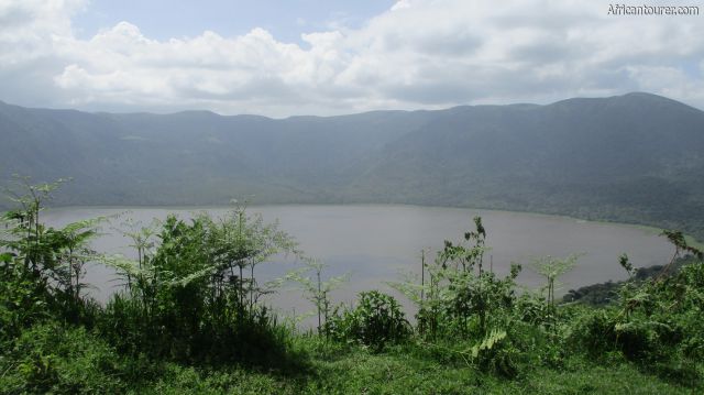
 Empakaai crater of Ngorongoro conservation area, a view of lake Empakaai from its eastern rim
- Empakaai crater of Ngorongoro conservation area, a view of the southern end from its eastern crater rim
- Empakaai crater of Ngorongoro conservation area, the northern end as seen from its eastern rim
- Empakaai crater of Ngorongoro conservation area, as seen from the entrance road on its eastern rim
- Empakaai crater of Ngorongoro conservation area, looking at its northern half from the eastern crater rim
- Empakaai crater of Ngorongoro conservation area, the start of the hiking trail into it from the eastern rim
- Empakaai crater of Ngorongoro conservation area, lake Empakaai (near) and the western rim in the distance
- Empakaai crater of Ngorongoro conservation area, the nothern half as seen from the start of the hiking trail into it from the eastern rim
- Empakaai crater of Ngorongoro conservation area, the southwestern wall as seen from the eastern rim
- Empakaai crater of Ngorongoro conservation area, in the distance, one of the special campsites located on its eastern rim
- Empakaai crater of Ngorongoro conservation area, on the far left - as seen from the road approaching it from Olmoti and Ngorongoro crater
- Empakaai crater of Ngorongoro conservation area, in the distance, with zebras grazing next to the road to it
- Empakaai crater of Ngorongoro conservation area, on the far left with Zebras and cows grazing near the road heading to it
- Empakaai crater of Ngorongoro conservation area, on the far left with mt. Lolmalasin on the far right
- Empakaai crater of Ngorongoro conservation area, on the far left with a herd of Thomson's gazelle grazing near the road to it
- Empakaai crater of Ngorongoro conservation area, looking at Oldoinyo Lengai (left) and the Kerimasi Crater (right) from its eastern rim
Altitude: 3220 m.a.m.s.l. (rim - highest)
Lowest point in lake - unknown
One of four volcanic calderas that are located in the Ngorongoro conservation area of northern Tanzania, the others being Ngorongoro and Olmoti and Kerimasi. Its rim is the highest of all in the area, and is the only one with a lake making up more than half of its crater floor.
All four calderas are described as volcanic highlands, as they are all located at higher altitudes than their surroundings. They also are inside the east African rift, sharing the same volcanic system as Lakes Eyasi and Natron, mt. Kilimanjaro.
The lowest part of Empakaai is the lake, about 2000 metres above sea level, and one of the main attractions inside the crater is the large number of Flamingos that can be found on its shores.
What to do thereThe crater is popular for walking safari's, where tourists get to hike deep for a day, and explore the lake and rain forest inside it. The only caveat being that you must be out by the end of the day - as the only campsites are special campsites on its rim.
As it is part of Ngorongoro conservation area, the crater holds a number of wild animals, requiring an armed ranger to accompany everyone who visits it.
Trips to the crater can also be part of an even longer walking safari which may last up to 5 days and end as far as lake Natron.
Best time to visitAny time of the year, with more emphasis towards the drier seasons of July to December each year, when the roads are more pliable throughout the park.
Location of Empakaai craterEmpakaai crater is located about 30km north east of Ngorongoro crater and in the Ngorongoro conservation area. Further down the road is the village of Naiyobi and Oldoinyo Lengai after that.
The vegetation inside the crater is mostly that of a rain forest, that changes from dense vegetation to smaller bushes as you near the crater floor and Lake Empakaai itself. Lake Empakaai has a sandy shoreline around it that is normally only accessible during the drier seasons, when the lake's water recede. Here there is little to no vegetation. For more information on its location, please see the map below.
How to get thereVia a 4x4 ride from one of the accommodations inside the conservation area or Loduare gate, all the way up to a point on top of the eastern rim. There are no tarmac roads in the area, thus you would have to traverse through bumpy dirt roads which are maintained every once in a while.
From here on wards, the journey continues on foot, through a hiking trail that takes you down the crater's steep slopes, culminating at the lake's shores. The whole hike takes about one to two hours depending on your fitness, but an armed NCAA ranger is required for any walking safaris inside the conservation area.
The hike back up is more difficult as the crater walls are very steep.
AbbreviationsNCAA - Ngorongoro Conservation Area Authority
m.a.m.s.l. - metres above metric sea level
Continue reading
Day
00:00
GMT
+z
Related places
We have no related places to show you
Popular spots