Ngurudoto craterArusha national park, Tanzania
 Ngurudoto crater of Arusha national park, as seen from the Leitong view point
 Ngurudoto crater of Arusha national park, the road to Leitong view point (after the fork)
- Ngurudoto crater of Arusha national park, view from a clearing in the forest on the way to Leitong view point
- Ngurudoto crater of Arusha national park, parking area at Leitong view point
- Ngurudoto crater of Arusha national park, path to Leitong view point at the top
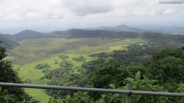
- Ngurudoto crater of Arusha national park, view from the railing at Leitong view point
- Ngurudoto crater of Arusha national park, another view from the Leitong view point
- Ngurudoto crater of Arusha national park, zoomed in photo of a small pond in the crater as seen from Leitong view point
- Ngurudoto crater of Arusha national park, a signpost at a fork in the road to the view points when coming from Ngurudoto museum
- Ngurudoto crater of Arusha national park, the climb to Rhino view point (top) from the road and parking area (behind and off view)
- Ngurudoto crater of Arusha national park, as seen from from the Rhino view point on the south eastern part of its rim
- Ngurudoto crater of Arusha national park, the view from Rhino view point on the south eastern part of its rim
- Ngurudoto crater of Arusha national park, the road to Mikindu view point from Rhino view point on the southern part of its rim
- Ngurudoto crater of Arusha national park, approaching Mikindu view point with baboons all over the benches
- Ngurudoto crater of Arusha national park, view from Mikindu view point
- Ngurudoto crater of Arusha national park, partial view of its floor with buffalos (far centre) grazing - as seen from Mikindu view point
- Ngurudoto crater of Arusha national park, view of its eastern half as seen from Mikindu view point
- Ngurudoto crater of Arusha national park, zoomed in photo of a herd of buffalos grazing on its crater floor as seen from Mikindu view point
- Ngurudoto crater of Arusha national park, the road while leaving the crater heading to Ngurudoto museum
- Ngurudoto crater of Arusha national park, 'leaving' - the road when headed to Ngurudoto museum from the southern part of its crater rim
Altitude 1824 m.a.m.s.l. (rim)
1520 m.a.m.s.l. (floor)
One of five beautiful volcanic calderas located inside the northern Tanzania region of Arusha, along with Ngorongoro, Empakaai, Maasai and Olmoti. With an approximate depth of 300 metres and a diameter of 3.2 km, it is more like a miniature Ngorongoro; However the floor of Ngurudoto is softer and otherwise unsuitable for driving on, leaving walking safaris as the only way of exploring it.
The actual volcano that formed it is now extinct, but from the pear shape of the present day crater floor, it seems that towards the end of its activity, there were two cones lying very close to each other. These then collapsed when the magma chamber underneath them withdrew to deeper levels - leaving them without support [1].
The crater is surrounded by a rainforest that is teaming with wildlife. This extends to cover part of the crater floor, with the rest being an evergreen swamp - which serves as a grazing ground for the onsite herd of buffalos. Other animals include several species of monkeys, birds, dik diks and even elephants that inhabit the forest, with the latter being the hardest to find.
There is a TANAPA made dirt road that lines up most of its rim, but unfortunately, most of the crater remains obscured from it by the forest. Only at five viewpoints can it's beauty be marvelled, with most of these being specially made areas - complete with parkings, benches, signposts and even a railing - for safety purposes. The viewpoints are:
At approximately 1824 m.a.m.s.l., the Leitong viewpoint is the highest and so far the most scenic of these, offering views of the snowy peak of mount Kilimanjaro, as well as the Momella lakes and agricultural settlements nearby.
What to do there?Drive or hike to several or all of the viewpoints and even the crater floor and enjoy its stunning flora and fauna. For those who would love a lengthy adventure, it is possible to hike to the crater floor, although you probably would need an armed ranger from Ngongongare gate as well as a payment of a hiking permit fee. This way, you could get closer to and see more wildlife than the usual drive can offer.
Alternatively, you could drive to any of the six viewpoints and see the crater from different angles, with more emphasis to the Leitong viewpoint. When done, you could either spend a night at one of the campsites, the rest houses, hotels or even continue on to visit the rest of the attractions in the national park.
Best time to visit?Any time of the year, with more emphasis to the drier seasons of July to February.
Weather is best during this time period, with walks being free of interruption from unexpected showers and the views being unobstructed by cloud cover.
Location of Ngurudoto craterThe Ngurudoto crater is located on the easternmost part of Arusha national park - Tanzania, just a hirty minutes drive from the foothills of mount Meru. It is also about 20 kilometres from mount Kilimanjaro as the crow flies. For more information on its location, please see the map below (click to start).
How to get there?By driving from one of the entry gates into Arusha national park, whether Ngongongare, Momela e.t.c., Since it is too far from either one to be able to walk there. The drive would normally take you past the Ngurudoto museum, where you could learn a bit more about the crater before actually heading to it.
The drive could either be made by a private vehicle (any kind), a rented one or a tours and travels one, although you may be required to pay for a vehicle entrance fee. Other fees payable at the time of writing include a conservation fee of TSHS 10,000 (East Africans) or USD 45 (other nationals), and a possible walking fee if going for a walking tour into the crater.
For more information on the park fees, please see the TANAPA website.References1. The 2017 park brochure by TANAPA
Other information from an actual visit to the crater
Abbreviationsm.a.m.s.l. - metres above metric sea level
TANAPA - Tanzania National Parks
1520 m.a.m.s.l. (floor)
One of five beautiful volcanic calderas located inside the northern Tanzania region of Arusha, along with Ngorongoro, Empakaai, Maasai and Olmoti. With an approximate depth of 300 metres and a diameter of 3.2 km, it is more like a miniature Ngorongoro; However the floor of Ngurudoto is softer and otherwise unsuitable for driving on, leaving walking safaris as the only way of exploring it.
The actual volcano that formed it is now extinct, but from the pear shape of the present day crater floor, it seems that towards the end of its activity, there were two cones lying very close to each other. These then collapsed when the magma chamber underneath them withdrew to deeper levels - leaving them without support [1].
The crater is surrounded by a rainforest that is teaming with wildlife. This extends to cover part of the crater floor, with the rest being an evergreen swamp - which serves as a grazing ground for the onsite herd of buffalos. Other animals include several species of monkeys, birds, dik diks and even elephants that inhabit the forest, with the latter being the hardest to find.
There is a TANAPA made dirt road that lines up most of its rim, but unfortunately, most of the crater remains obscured from it by the forest. Only at five viewpoints can it's beauty be marvelled, with most of these being specially made areas - complete with parkings, benches, signposts and even a railing - for safety purposes. The viewpoints are:
- Rhino in the southern rim
- Mikindu also in the southern rim
- The rock in the southern rim
- Bufalo (southern rim)
- The glades in the northern rim
- Leitong in the northern rim
At approximately 1824 m.a.m.s.l., the Leitong viewpoint is the highest and so far the most scenic of these, offering views of the snowy peak of mount Kilimanjaro, as well as the Momella lakes and agricultural settlements nearby.
What to do there?Drive or hike to several or all of the viewpoints and even the crater floor and enjoy its stunning flora and fauna. For those who would love a lengthy adventure, it is possible to hike to the crater floor, although you probably would need an armed ranger from Ngongongare gate as well as a payment of a hiking permit fee. This way, you could get closer to and see more wildlife than the usual drive can offer.
Alternatively, you could drive to any of the six viewpoints and see the crater from different angles, with more emphasis to the Leitong viewpoint. When done, you could either spend a night at one of the campsites, the rest houses, hotels or even continue on to visit the rest of the attractions in the national park.
Best time to visit?Any time of the year, with more emphasis to the drier seasons of July to February.
Weather is best during this time period, with walks being free of interruption from unexpected showers and the views being unobstructed by cloud cover.
Location of Ngurudoto craterThe Ngurudoto crater is located on the easternmost part of Arusha national park - Tanzania, just a hirty minutes drive from the foothills of mount Meru. It is also about 20 kilometres from mount Kilimanjaro as the crow flies. For more information on its location, please see the map below (click to start).
How to get there?By driving from one of the entry gates into Arusha national park, whether Ngongongare, Momela e.t.c., Since it is too far from either one to be able to walk there. The drive would normally take you past the Ngurudoto museum, where you could learn a bit more about the crater before actually heading to it.
The drive could either be made by a private vehicle (any kind), a rented one or a tours and travels one, although you may be required to pay for a vehicle entrance fee. Other fees payable at the time of writing include a conservation fee of TSHS 10,000 (East Africans) or USD 45 (other nationals), and a possible walking fee if going for a walking tour into the crater.
For more information on the park fees, please see the TANAPA website.References1. The 2017 park brochure by TANAPA
Other information from an actual visit to the crater
Abbreviationsm.a.m.s.l. - metres above metric sea level
TANAPA - Tanzania National Parks
Continue reading
Popular spots