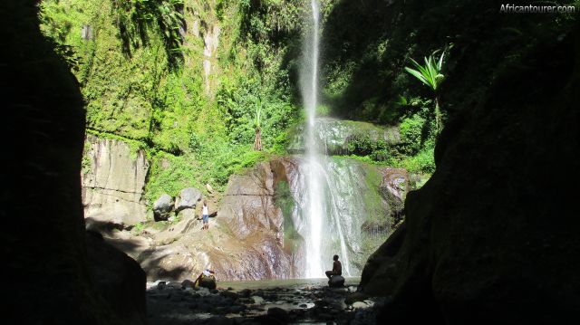
Napuru waterfallArusha, Tanzania
 Napuru waterfalls of Arusha national park, as seen from the access path
 Napuru waterfalls of Arusha national park, a view of the top half
- Napuru waterfalls of Arusha national park, as seen from the entrance road to it
- Napuru waterfalls of Arusha national park, a view of the top half on a clear sunny day
- Napuru waterfalls of Arusha national park, view from a ledge behind the falls (left)
- Napuru waterfalls of Arusha national park, view of the plunge pool close up
- Napuru waterfalls of Arusha national park, view of the bottom half and plunge pool
- Napuru waterfalls of Arusha national park, the river a short distance downstream from it
- Napuru waterfalls of Arusha national park, the Themi river downstream from the falls
- Napuru waterfalls of Arusha national park, the Themi river and hiking path to the falls
- Napuru waterfalls of Arusha national park, 'up the ladder' on the hiking path to the falls
- Napuru waterfalls of Arusha national park, the path through the Themi river valley heading to the falls
- Napuru waterfalls of Arusha national park, a boulder next to the hiking path to it
- Napuru waterfalls of Arusha national park, a section of the hiking path to it on the Themi river valley
- Napuru waterfalls of Arusha national park, 'walking on rocks' - the hiking path to it
- Napuru waterfalls of Arusha national park, river rocks on the hiking path to it through the Themi river valley
- Napuru waterfalls of Arusha national park, a smaller stream that feeds water into the Themi river
- Napuru waterfalls of Arusha national park, a section of the Themi river valley that also serves as the hiking route to the falls
- Napuru waterfalls of Arusha national park, 'calm and sunny' a pool of water on the hiking path to it
- Napuru waterfalls of Arusha national park, Themi river waters as seen enroute to the falls
- Napuru waterfalls of Arusha national park, the top half of a smaller waterfall seen on the way there
- Napuru waterfalls of Arusha national park, a smaller waterfall on the way there
- Napuru waterfalls of Arusha national park, the Themi river valley and hiking path to it.
- Napuru waterfalls of Arusha national park, a section of the hiking path to it
- Napuru waterfalls of Arusha national park, a makeshift stairway on the hiking path to it
- Napuru waterfalls of Arusha national park, the start of the hiking path from Napuru picnic site
- Napuru waterfalls of Arusha national park, View of Napuru picnic site on the way to the falls (behind)
- Napuru waterfalls of Arusha national park, view of Napuru picnic site on the way to the falls
- Napuru waterfalls of Arusha national park, benches at the Napuru picnic site - on the way to the falls
- Napuru waterfalls of Arusha national park, from right, the barbecue hut and toilets at Napuru picnic site - the start of the hiking route
Altitude: 1760 m.a.m.s.l.
A beautiful waterfall on the slopes of mount Meru, that normally requires a short walk to get to. It is part of the early stages of the Themi river, that flows through Arusha's city centre and into its southern outskirts.
What to do there?Hike to the falls and enjoy the beautiful scenery, or take a dip if you feel like. The hike takes you through the Themi river valley, one of the only ways to access the enclosure where the falls are located, so wear your hiking boots.
No special tools or climbing skills are required to get there, but a bit of stamina is necessary to make your way through a valley filled with pebbles, rocks and boulders - some of which may be slippery.
But when you finally get there, a picturesque scene awaits you. Just remember to get your permits from the ranger post at Napuru picnic site or TANAPA before heading out.
Best time to visit?Any time of the year, but as you will be walking through a river valley for most of the way, the drier season would mean less slippery surfaces along with the reduced possibility of getting wet from sudden showers.
Location of Napuru waterfallThe Napuru waterfalls are located on the slopes of mount Meru, a few kilometres north of the city of Arusha. It also is inside a TANAPA zone, which we think is the south western part of Arusha national park. For more information on its location, please see the map below.
How to get there?By driving or hiking. There are two routes that you can use to get to the falls, one of which has a turning point heading north at mount Meru hotel, taking about a 15 minute drive up a steep sloped dirt road, all the way to the Napuru picnic site.
Here lies a ranger's post where you can get your permit from and if you know your way, hike to the falls. If you would like a tour guide then you could get one at Themi falls leisure park or ask for one at the picnic site.
The other route starts from a village north of the Sanawari area, following a small path on top of Oldonyo Sapuk. You probably would need a guide to get you through this as it uses a network of paths used by villagers that only a local would know how to navigate. This is a hiking only path and there are no driving routes.
Abbreviationsm.a.m.s.l. - metres above metric sea level
Continue reading
Day
00:00
GMT
+z
Related places
Themi falls leisure parkNapuru picnic site by themi falls leisure parkThemi waterfall
Popular spots